
ECO offers Canadian strategic media advice. We do release distribution by fax, email, online and Google News.
Toronto: 416.972.7404
Sudbury: 1.800.494.4199
distrib@ecostrategy.ca
Omushkego Wahkohtowin
The term “Omushkego” means “the strong people” and is the name that Cree in the region use to describe themselves. “Wahkohtowin” refers to correct relationships between people and the natural world.
The Mushkegowuk Council has embarked on a project – the Omushkego Wahkohtowin – to plans for the lands and waters of the Omushkego Cree. Such a land use plan, agreed between the Omushkego communities and the federal and provincial governments would create the conditions for achieving predictability and stability in the Omushkego Homelands alongside economic development.
The Mushkegowuk Council represents the First Nations of Chapleau, Missanabie, Taykwa Tagamou, Moose Cree, Kashechewan, Fort Albany, and Attawapiskat. These First Nations are joined in this project by the First Nations of Weenusk and Fort Severn.
The authority to advance this initiative comes from the Elders, Band Council and Mushkegowuk Council Resolutions dating back many years. The Omushkego recognize the 1905 treaty 9 as the basis for sharing their lands, but they did not give up jurisdiction under the treaty.
Critical mineral interests overlap with the project area. The Mushkegowuk Council sees this project as a way to help certainty for where development should take place. The Council does not see conservation and development as opposing interests. It supports conservation and development. The communities involved in the project would use land use planning to identify areas for conservation as well as areas where development can happen.
Like industry, the Omushkego are seeking certainty for a stable future for their children rooted in Omushkego culture, good schools, safe housing and clean drinking water. The Mushkegowuk leadership must also guard the inherent and treaty rights of the Omushkego, including to hunt and fish. People in Omushkego communities rely on the lands and waters for food security.
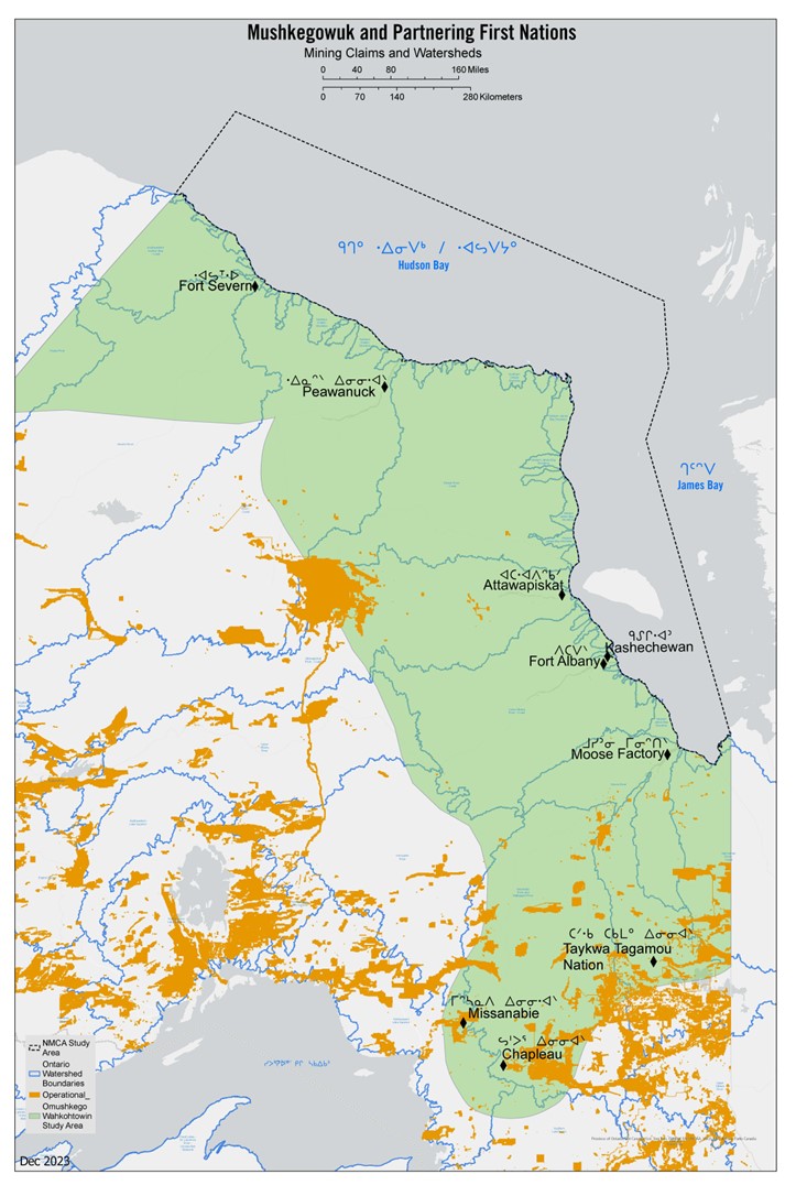 This map identifies areas staked for mineral development (in yellow) as of December 2023. The area in green corresponds to the homelands of the First Nations participating in the development of the Omushkego Wahkohtowin, and the offshore area shows the proposed NMCA. |
Omushkego Wakhotowin facts
The wetlands of the region are a portion of the largest wetland complex in North America, which is the third largest in the world overall. It contains the second-largest carbon sink in the world, sequestering approximately 35 gigatons of carbon within its peatlands. 1,287 km of tidal seacoast are in the project area, roughly the distance between Toronto and either Winnipeg or Halifax The waters contain 20% of Canada’s beluga whales This is home to the southernmost population of polar bears in the world, some travel as far as 150 km inland along the waterway corridors It is important spring and summer habitat for as many as 16,000 southern Hudson Bay caribou. This area is a hotspot used by hundreds of species of breeding and migratory birds 2-3 million migratory snow geese migrate through in the spring and fall The two bays drain some of Canada’s largest undammed rivers – Severn, Winisk, Attawapiskat, Ekwan and Albany – where the mixing of salt and freshwater results in remarkable productivity for a northern high latitude location. |
In addition to this website, we also do fax and email distribution. Call us for a quote on your distribution needs at 416-805-7720 or email us at huffd@ecostrategy.ca.